search for a Trip
Introduction of Turpan
Turpan is a remote desert city in the far west of China, one of the lowest places on earth, where rain never falls and summers are scorching hot. Located three hours drive East of Urumqi in Xinjiang Province, some 250 miles inside the Takelimakan Desert, Turpan, which has a long history, was once an important staging post on the ancient Silk Road. It is one of Xinjiang's most fascinating cities, known for its strange landscape, wealth of places of historical interest, abundance of fruits and rich resources of ethnic culture. Many monuments bear witness to the importance of Turpan as a Silk Road city. There are 14 unites of the cultural relies, which are the protected by the country. The Flaming Mountain, the artistically built Imin Minaret, the ancient cities of Jiaohe and Gaochang, the ancient tombs of Astana, the Beziklik Thousand-Buddha Grottoes and the special underground irrigation system-karez are of great value and enjoying value. Besides, the folk customs such as folk dance under grape trellises.
Main Attractions in Turpan
 46 kilometers southeast of Turpan near the "Flaming Mountains" seats an impressive ruin of the Ancient City of Gaochang. Built in the first century B.C., it used to be a garrison town and later became a key point along the ancient Silk Road. The city was burnt down around the 14th century. The ruins originally consisted of three parts: the inner and outer cities, and a palace complex. Nine city gates were built on cardinal points, three in the south and two in each other three directions respectively. Visitors are usually suggested to enter the best preserved one in the west to the core. The best preserved structures in the ruins are two temple/monasteries in the southwest and southeast corners of the outer city section. In the southwestern temple, the front gate, courtyard, lecture hall, main hall, and monastic dormitories are relatively intact. The southeast temple has the only preserved fresco in the ruins.
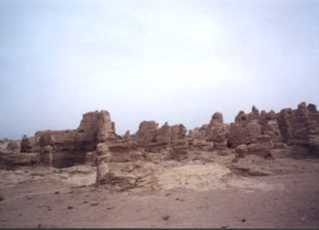
 The Ancient City of Jiaohe stands isolated on a 30-meter-high plateau in the Ya'ernaizi Valley, 13 kilometers east of Turpan. The city is situated on an island between two rivers and was initially built about 2000 years ago and for a long period of time. The city, situated along the silk road, was of great military significance and played a pivotal role in the economic development of Western and Eastern countries. Since its decline, what was left of the city has steadily deteriorated. At present, natural forces threaten the site erosion by gale force winds which blow dust and sand against the walls and fill the streets and courtyards with sand. Erosion of the cliffs by floodwater, threatening them with collapse, is the most serious and urgent threat to the ruins.
Today, this is a well preserved site and a more atmospheric spot to wander and imagine times gone by then the city at Gaochang. Well preserved temples, pagodas and streets are dotted around. A Buddhist monastery marks the center of the city and there are some ancient filled wells here too. The crumbling sand colored walls of the buildings reflect the color of the desert and the surrounding sand dunes. Allow at least one hour to explore this intriguing city.
Astana Tombs:
These graves lie 40 kilometers (25 miles) southeast of Turpan, 6 kilometers (3.7 miles) from the ancient city of Gaochang. The imperial dead of Gaochang and noble officials were buried here. The tombs have been blessed with centuries of dry weather.
The Emin Minaret (Emin Ta), just 2km east of Turpan, consisted both a mosque and a minaret tower built in 1778 by the local Muslim ruler, Emin Hoja. Also known as Sugong Tower after Emin's Chinese name, the minaret was built in a simple Islamic style. It is circular, 44 meters in height, and 10 meters in diameter at the base. Unfortunately, the minaret is no longer open to the public in an effort to preserve the structure; however, you can view the surroundings from the roof of the mosque. As for the mosque, although it is rather bare inside, services are held every Friday and on holidays.
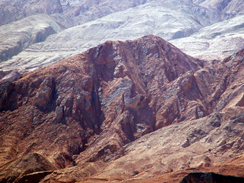
The Flaming Mountains are one of the branch ranges of the Tianshan Mountains, lying in the middle of the Turpan Depression and running from east to west for about 100 kilometers with its extreme width of 10 kilometers. Its highest peak is 40 kilometers east of the city of Turpan and 831.7 meters above sea level. Crystal movements and years of efflorescence fashion its unique geological feature. When the sun rays beat down in mid-afternoon, the red rocks on the crisscross gullies and ravines reflect and the heat is intense as if the hillsides were engulfed by tongues of fire, hence the name.
The Ancient Karez system is comprised of a series of wells and linking underground channels that uses gravity to bring ground water to the surface, usually far from the source. In Turpan city there are more than 470 systems, totaling over 1,600 kilometers of tunnels. It is considered as one of the three great projects in China with the other two being the Great Wall and the Grand Canal. The history of Karez can be traced back to the Han dynasty. Most of karezes existing today in the Turpan were built in the Qing dynasty.
Lying at the base of the western end of Flaming Mountains is a world of unique with vineyards and fruit trees - Grape Valley. The Grape Valley of the Flaming Mountains, fifteen kilometers from the city center, is a world of unique beauty, presenting a striking contrast with the hot, dry and barren outside. Cushioned by green grass and graced with green trees, the valley is a world of green wit brooks, canals and sparkling springs; there is a poetic flavor to the idyllic beauty of the valley. Scattered everywhere in the valley are trees: mulberry, peach, apricot, apple, pomegranate, pear, fig, walnut, elm, poplar and willow; also watermelons and muskmelons, making the valley into a "garden of one hundred flowers" in spring and an "orchard of one hundred kinds of fruits" in summer. In the valley there is a reception center where dense grapevines interweave with each other and winding paths lead to secluded places with clusters of grapes within easy reach.
Bezeklik Thousand Buddha Caves
56 kilometers (35 miles) northeast of the Turpan, Bezeklik Thousand Buddha Caves contain 67 caves dating from the Northern and Southern dynasties (317 - 589) to the Yuan dynasty (1279 - 1368). In the Uigur language Bezeklik means "place where there are paintings" It used to be an important center for Buddhist worship under the Xizhou Huigu government of Gaochang Kingdom, which built the royal temple of the King of Huigu at this site. The caves are well hidden and rest on a long ridge overlooking a valley where the monastery was located. Originally it is accessible via a winding pathway to the cliff top, and a steep stairway led down to the monastery 30 feet below. Among 83 numbered grottoes, about 40 of them have rich remains of murals. Some murals present clearly the figurines of the Huigu people; some showed Indian monks and portraits of Buddhas at different periods throughout history. They are briefly divided into four periods chronologically.
Turpan Climate
|
Month |
Jan |
Feb |
Mar |
Apr |
May |
Jun |
Jul |
Aug |
Sep |
Oct |
Nov |
Dec |
|
Temperature (Celsius) |
-4.6 |
-2.2 |
4.5 |
15.1 |
19.8 |
24.0 |
30.8 |
33.4 |
25.4 |
19.4 |
10.1 |
-2.7 |
China Attractions Guide
- Anhui Attractions
- Beijing Attractions
- Chongqing Attractions
- Fujian Attractions
- Gansu Attractions
- Guangdong Attractions
- Guangxi Attractions
- Guizhou Attractions
- Hainan Attractions
- Henan Attractions
- Hongkong Attractions
- Hubei Attractions
- Hunan Attractions
- Inner Mongolia Attractions
- Jiangsu Attractions
- Jiangxi Attractions
- Manchuria Attractions
- Ningxia Attractions
- Qinghai Attractions
- Shaanxi Attractions


