




search for a Trip
Introduction of Kashgar
Kashgar is located at an elevation of approximately 1,300 meters (4,265 feet) on the banks of the Tuman River, in the heart of a fertile oasis surrounded by cotton fields and agricultural land in China’s Xinjiang Uygur Autonomous Region. For centuries, Kashgar has been one of the most important oasis cities along the ancient Silk Road. The city has a population of around 240,000 people, with the Uyghur community forming a significant part of its rich cultural heritage.
Throughout its long history, Kashgar has served as a vital crossroads linking China with Central Asia, South Asia, and the Middle East. Its strategic location places it closer to cities such as Moscow, Islamabad, New Delhi, Kabul, and Tehran than to Beijing, highlighting its unique position at the meeting point of civilizations. Today, visitors are drawn to Kashgar’s historic Old City, vibrant bazaars, distinctive Islamic architecture, and enduring Silk Road traditions, making it one of the most fascinating cultural destinations in western China.
Main attractions in Kashgar
Id Kah Mosque
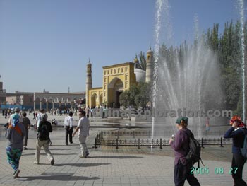 The Id Kah Mosque is the largest mosque in China and the religious center of Kashgar. The call to Prayer booming from the mosque can be heard throughout the city center. It is said that this place was once a cemetery. The present Id Kah Mosque was built in 1442 as a very small structure. Several renovations and enlargements have created it with today's scale and style. The whole complex occupies 16,800 square meters (about 4 acres) and consists of the courtyard, the Hall of Prayer, and the gate tower and as well as some other attached structures. The mosque exemplifies grand Islamic architecture, with a rectangular entranceway, flanked by intricately designed, slender minarets. The facade of the mosque is filled with yellow and white tiling, interspersed with designs in blues and greens. Inside the mosque there are charming courtyards and gardens where worshippers assemble before entering the halls.
Karakuli Lake
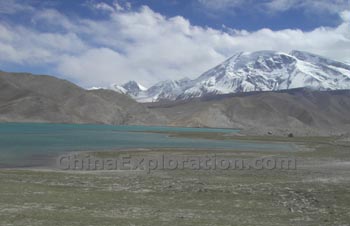
The lake's name in local languages is: Kara Kul, literally: "Black Lake". Kara Kul is located about 200 kilometers from Kashgar in the Pamir plateau Range just off the Karakoram Highway (KKH). Kara Kul's elevation is about 3645 meters. The area of Kara Kul next to the KKH is becoming more cluttered with trashy development, but don't let that deter you. The mountain setting is stunning as both Kongur (7719m) and Muztagh Ata (7546m) are visible from the lake. It is possible to trek away from the lake and avoid the developments and trash. The locals inhabiting this area are Kirghiz shepherds. Along the KKH they will likely try to sell you jewelry, rugs and camel rides. Some of their embroidery can be a good deal.
Abakh Hoja Tomb
The Tombs, five km to the northeast of Kashi, are the cemeteries of an Islamic saint and his 72 descendants. The cemetery includes tombs, a gate tower, a recitation hall, a mosque, a fountain and an orchard. It was first built in 1640.
Kashgar old town
Kashgar old town is located at a precipitous position with mud-thatched buildings densely built one atop another. It contains a large group of Uygur residential houses . The Old Town city is now home to 630 homes with more than 2450 people, all of whom are Muslims. The town has a history of over 2,000 years. It was said that Banchao, Eastern Han's envoy to the Western Region once stayed here on his way. It was a summer palace during the Kalahan Dynasty.
Climate of Kashgar
|
Month |
Jan |
Feb |
Mar |
Apr |
May |
Jun |
Jul |
Aug |
Sep |
Oct |
Nov |
Dec |
|
Temperature (Celsius) |
-6.6 |
-5.2 |
4.5 |
15.1 |
19.8 |
24.0 |
27.8 |
26.4 |
20.4 |
15.4 |
11.1 |
-1.0 |
Click to see kashgar tours
China Attractions Guide
- Anhui Attractions
- Beijing Attractions
- Chongqing Attractions
- Fujian Attractions
- Gansu Attractions
- Guangdong Attractions
- Guangxi Attractions
- Guizhou Attractions
- Hainan Attractions
- Henan Attractions
- Hongkong Attractions
- Hubei Attractions
- Hunan Attractions
- Heilongjiang Attractions
- Inner Mongolia Attractions
- Jiangsu Attractions
- Jilin Attractions
- Jiangxi Attractions
- Liaoning Attractions
- Manchuria Attractions

