search for a Trip
Introduction of Garze Tibetan Autonomous Prefecture
Ganzi, also called Garze Tibetan Autonomous Prefecture of Sichuan Province lies on the Kang-Tibetan Plateau where the Hengduan Mountain Ranges meet from the north to the south with the southeastern range of the Qinghai-Tibetan Plateau known as” the third pole of the earth ”.This is a piece of thick land closest to the shining and hot sun on the earth. Under the bright sun and blue sky, snow mountain peaks, roaring and rushing rivers, flowery and grassy plateaus, all splendid and mysterious, give birth to totally different local culture and art, and unique customs and habits of the land. Former Chinese Premier Zhu Rongji called it Fairy Mountains and Holy Land.
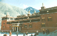
On this land with an area of 153,700 square kilometers, magnificent mountains and rivers reflect human material civilization. Majestic buildings at the foot of the crystal snow peaks, love songs and dances on the wild land with waves of grass and flowers demonstrate the vitality of mountains and waters on the Kang-Tibetan Plateau, and the true love of the world. Over the ages, the animal of the nature combines perfectly and harmoniously with human wisdom: man of wisdom is endowed with the bold and unconstrained character of mountains and rivers, just as the latter has been gifted with human emotion and intelligence. They together make a wonder world of Kang-Tibetan holy land.
There are 18 counties in this wide land: Kangding, Luding, Jiulong, Luhuo, Daocheng, Litang, Seda , Danba, Yajiang, Dege, Shiqu ( Serxu ) , Ganzi ( Garze ) , Batang, Xiangcheng, Derong, Xinlong, Baiyu, Daohu ( Dawu )
Main attractions and important cities in Garze
Introduction about Seda county
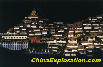 Seda, the Tibetan meaning – gold horse, lies in the southeast of Qingdao – Tibet plateau, the northeast of Ganzi Tibetan autonomous prefecture, Sichuan Province. Located at the link between Sichuan province and Qinghai Province, Seda covers 9338.98 sq. km, has a population of 36,000, and includes 17 towns, 66 villages, with Seke town’s elevation 3893 meters.
Seda has convenient transportation and communication. The county combines with the national highway 317 through Road Se-Se (from Seda to Se erba) in the east, with national highway 318 through Road Se-Huo (from Seda to Luhuo), Road Se-Gan (from Seda to Ganzi) in the south. In the west it reaches Dari town of Qinghai province by Road Da-Da (from Seda to Dari). In the south Seda and Banma town (Qinghai province) are connected by Road Se- Nian (from Seda to Nianlong). Seda, in which blacktop has covered 224 km, has become the important Northern door from Sichuan to Qinghai. At the same time,cable communication has covered the whole county and all of the towns along Road Se-Se. China mobile and China Telecom communication is available in the county.
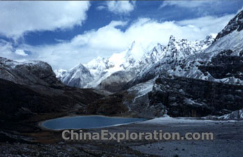 Seda’s abundant natural resources have great potential. As one of the greatest stock-breeding counties in Sichuan, the exploitable grassland covers an area of 13 million mu; more than 500,000 yaks and Tibetan sheep-goat are on hand. Among the mineral resources: gold, silver, copper, sternum etc., gold has largest amount with high quality, which gives Seda an honorable name- Gold Grassland. The woodland covers an area of 1.68 million mu, cumulative forest 2 million stere. The four rivers, Daqu, Niqu, Sequ, Duke, run through the county with water energy 640,000 kw.. More than 50 kinds of wind animals such as ounce, river deer, thorold’s deer, Tibetan macaque, otters can be found in Seda, also it grows valuable Chinese traditional herbs, such as Chinese caterpillar fungus, the bulb of fritillary, and biological materials ® C mushroom, monkey head mushroom, glossy ganoderma mushroom.
Seda has long history of Tibetan culture. The hand-written copy “Ge Sa er Tale” has more than 20 editions. There are a number of civil performers and dignitaries working on Ge Sa er culture and the relics are all over the county. Seda’s Ge Sa er opera, the northern clique Tibetan opera with style, honored by some national ministry for many times, has great fame worldwide and nationwide and won Seda the name –“Hometown of Ge Sa er Opera”.
Seda has elegant landscape and simple custom. People will be impressed with Ge Letuo’s “Leqiong”, autumn scenery of Jianxue, five-color sea of Huoxi, celestial burial of Luoruo, grassland scene of Seke, divine mountain of Zuri, primeval forest of Nianlong, stone inscription of Niduo, Nila late, etc.
Garze County:
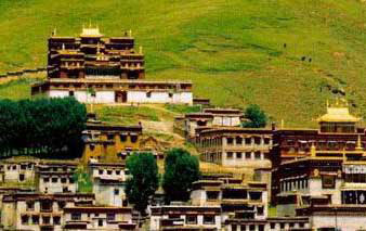 Ganzi, in Tibetan it means pure white and beautiful. It is located in the upper reaches of Yalong river, northwest of Ganzi Tibetan autonomous prefecture of Sichuan Province, it occupies the center position of north route of Chuan-Tibetan highway, 385 kilometers from Kangding, the capital of autonomous prefecture, 752 kilometers from Chengdu, reputable as the commercial center, tourism center and wholesale center of goods of north Ganzi Tibetan autonomous prefecture. There are Bayankala mountain range in the north of Ganzi, Guola mountain renge in the east and Shaluli mountain range in the south. Encircled by the snow-covered mountains, it is always the holy contested spot of military commanders.
Ganzi has a long history, ancient Tibetan people multiplied and lived here before the warring states period in the Sui Dynasty it was Baili kingdom. In 1253 A.D. Baili kingdom submitted itself to Yuan Dynasty, and administrated by marshal Duogans’ office. In the year of 1640 ( the 13th year of Congzhen’era, Ming Dynasty), the fifth Dalai and fourth Bainqen asked Gushihan the head of tribe of Mongolia to eliminated Baili kingdom,
It is a place with remarkable places and outstanding people. It is also the homeland of Tibetan step dance a unique form of dance on Qinghai-Tibetan Plateau. Beautiful Yalong river, Daqu river, Niqu river breed the luxuriant forest and grassland, numerous hot springs distribute everywhere such as the outdoor bathing place of Geothermol power of Gange. It is also the homeland of the founder of reincarnation of living Buddha of Tibetan Buddhist-Gemaba, Dusongqinba. It is also the place with the ancient and dense Kangba culture on horse’s ancient way of tea, ancient temple, famous shrines and magical story, etc.
Daocheng
Daocheng County lies in Ganzi Tibetan Autonomous State, in the southern Sichuan Province, China. Daocheng County is situated in the southern Qinghai-Tibetan Plateau, on the eastern side of Cross Mountains, bordering Zhongdian of Yunnan to the southwest. Here, with the background of thick mountains and green meadow, the peaks ate covered with white snow all the year round, the sea of cloud and fog is changeable, the waterfalls are distributed high and low.
Also there is enchanting South water countryside. Between the altitudes of 6032 meters to 2000 meters is distributed many climatic zones and plant zones which are banks with rich species genes.
There are 14 temples, big or small, at Daocheng County. Besides red Christianity, Hua Christianity, White Christianity and Yellow Christianity, there is a primitive religion---Ben Christianity. A lot of antiques are treasured up here.
The untouched ground—the last Shangrila is just expecting friends from all over the world to appreciate its brilliance and colorfulness.
Serxu - Home of the Sun Tribe in West China
Serxu lies in the northwest of Sichuan province on the boundary of Sichuan, Qinghai and Tibet. It belongs to Ganzi Tibet autonomous region and a part of the main body of Qinghai-Tibet Plateau. The average elevation of landscape area is 4000 meters and the whole county has an area of 25141 square kilometers. Tashika Grassland of Serxu, the largest one in Sichuan province, occupies nearly 90% of total area of the county.
“Tashika” is another name of Serxu. It means “the bank of Yalong River”. With the beautiful sunshine, lush pasture, charming sight and well-protected natural ecology, Tashika Grand Grassland is the paradise of wild animals. It also brings up 18 nomadic tribes looking for water and grass to settle down, so the humane landscape has the unique charm.
The sun and fire is the totem of Kangba people, so Tashika has a more resounding name---“the Sun Tribe”. When more and more Tibetans give up the nomadic life and begin to settle down in big cities or small counties, you can go to Srxu to experience the pasture nomadic tribe’s life which is full of freedom, passion and primitiveness and feel the touch of the divinities…
Serxu, with her beauty and marvel, allures and attracts every traveler.
Hailuogou Glacial Forest Park
With an altitude of 7556 meters, Gongga Mountain is the main one of Hengduan Mountain Ranges and also the highest peak in the eastern part of Qinghai-Tibetan Plateau and Sichuan province. It is named “the king of Shu Mountains”. Its main peak seems great, elegant and saintly whether in the air, mist or in the sky with stars.
Gongga Scenic Spots have 71 glaciers with an area of 255 km2, which is the largest oceanic glaciers group in Hengduan Mountain Ranges and eastern Qinghai-Plateau. Among them, Hailuogou No. 1 glacier is the largest, longest and the most magnificent one. It is important part of Hailuogou Glacial Forest Park and a rare modern glacier with low latitude and low altitude, which can be climbed up all the year round founded till now in the world.
The Great Glacier Fall, important part of Hailuogou glaciers, is located in the place of 3720-4800-meter altitude below the main peak of Gongga Mountain. It is 1080 high and 1100 wide. It is the largest glacier fall that can be viewed in the world. When peculiar ice fall occurs, snow pieces dance glittering blue and make great noise. Its vigor is majestic enough to shake the world.
The ice tower forest and glacial city gate hole on glaciers are the most worthy of view and participation. Ice tower forest is formed gradually by movement and melt of glacial fault ages for a thousand years. Glacial city gate hole, located at the end of glacial tongue with dozens-of-meter thickness, is formed by erosion of underground glaciers.
Hailuogou Glacial Forest Park has a unique sight of hot mineral with large fluxes, which are located at the altitude of 2600 meters, 1900 meters and 1530 meters. The temperature of water mouth is high to 92 ℃, which is near to the local boiling point, so it is called as “boiling spring”.
The virgin forests in Hailuogou cover an area of 70 km2. It is one of the regions where ancient and primitive species are conserved most. Here various kinds of wild ornamentals compete with their beauties and decorate Hailuogou into a multi colored world. At the same time, Hailuogou is the habitat of many rare animals.
Hailuogou Glacial Forest Park is situated in Ganzi Tibetan Autonomous Prefecture in Sichuan with dense Kangba Tibetan flavors. On this promising tourist line sprinkle Rice City. Yading Scenic Spots, Tagong Plateau, Mugecuo Scenic Spots, Kangding Town the hometown of ballad and Luding Iron Rope Bridge…Let’s meet on Gongga Mountain and enjoy the mysterious Kangba feelings!
Yading Nation Park:
“As the highest and most dramatic features of the natural landscape, mountains have an extraordinary power to evoke the sacred. The ethereal rise of a ridge in mist, the glint of moonlight on an icy face, a flare of gold on a distant peak - such glimpses of transcendent beauty can reveal our world as a place of unimaginable mystery and splendor. In the fierce play of natural elements that swirl about their summits -thunder, lightning, wind, and clouds -mountains also embody powerful forces beyond our control, physical expressions of an awesome reality that can overwhelm us with feelings of wonder and fear. ” Westerners used to describe Yading as above. Yading is located in Daocheng county in west of Sichuan province bordering with Yunnan Shangrila country. In the huge Konkaning Peaks, the three peaks of Xianlairi, Xialuoduojie and Yangmaiyong standing in the sky like armed gods guarding this sacred land. The locals adored the three peaks as Chenrezigs, Chanadorje and Jampayang.
Click to see more Chengdu Tours
China Attractions Guide
- Anhui Attractions
- Beijing Attractions
- Chongqing Attractions
- Fujian Attractions
- Gansu Attractions
- Guangdong Attractions
- Guangxi Attractions
- Guizhou Attractions
- Hainan Attractions
- Henan Attractions
- Hongkong Attractions
- Hubei Attractions
- Hunan Attractions
- Inner Mongolia Attractions
- Jiangsu Attractions
- Jiangxi Attractions
- Manchuria Attractions
- Ningxia Attractions
- Qinghai Attractions
- Shaanxi Attractions

